ESSO - Indian National Centre for Ocean Information Services
(An Autonomous Body under the Ministry of Earth Sciences, Govt. of India)
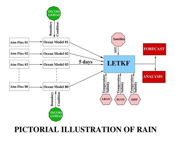
RAIN (Regional Analysis of Indian OceaN)
RAIN (Regional Analysis of Indian OceaN) is a data assimilation system developed in INCOIS wherein ROMS (Regional Ocean Modeling System), which is an ocean general circulation model suited for regional basins and is used as a forecast model for Indian Ocean by INCOIS, is interfaced with the data assimilation scheme of Local Ensemble Transform Kalman Filter (LETKF). LETKF is a smart and efficient variant of the textbook ensemble Kalman Filter. RAIN comprises of 80 ensemble members, i.e., 80 similar replicas of the model evolve in time starting from slightly different initial conditions. The physical parameters like tracer diffusion coefficients, viscosity coefficients etc and mixing parameterization schemes also slightly differ across the ensemble members. This strategy aids in exploiting the benefits of varied mixing parameterizations and also helps in maintaining a healthy spread across the ensemble members. A healthy spread plays a pivotal role in arresting filter divergence. The ensemble members are forced every 6 hourly by 80 ensembles of fluxes from the atmospheric model GFS operated by National Centre for Medium Range Weather Forecasting (NCMRWF). Identical boundary conditions, derived from INCOIS-GODAS, are fed to all the ensemble members. This system generates ocean state vectors of the Indian Ocean basin (30°N - 30°S; 30°E - 120°E) on a regular grid with an horizontal length scale of ~ 9 km while the ocean is vertically sliced into 40 levels.
The model ensemble runs for 5 days and the assimilation is performed every fifth day thereby generating an ocean analysis. Satellite swath data of sea surface temperature (SST) along with temperature and salinity profiles from Argo floats, Moored buoys and ship tracks are assimilated into the system. An improved representation error has been derived for the observations that varies across space and time. Since the ocean model set-up is not forced with river discharge fluxes, the sea surface salinity (SSS) is relaxed to World Ocean Atlas (WOA) monthly climatology over a relaxation time scale of 30 days.
RAIN provides an improved initial condition (ensemble mean of analyses) to the operational ocean forecast model ROMS. RAIN also provides an improved analysis of the Indian Ocean basin. The analysis is available from August 2016 onwards.
RAIN in a Nutshell
|
Model &Resolution |
Domain |
Forcing |
Boundary Condition |
Assimilation Scheme |
Assimilated Observation |
Assimilation Frequency |
|
ROMS |
Indian Ocean |
80-member NCMRWF ensemble flux from ensemble GFS model |
Derived from INCOIS-GODAS |
Local Ensemble Transform Kalman Filter (LETKF) |
1)Temperature Profiles |
5 days |